Hillshade (elevation model)
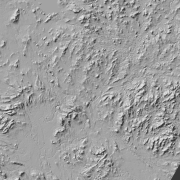
Hillshade (elevation model) is a raster dataset visualising the elevation of the terrain. There are five product versions available in which the pixel sizes are 2, 8, 32, 64, 128 and 512 metres. Pixel size 2 m has been produced of the dataset Elevation model 2 m. The other sizes have been produced of the dataset Elevation model 10 m. The material does not contain elevation values; it is a greyscale image that visualises the direction and steepness of hills.
The product belongs to the open data of the National Land Survey of Finland.
Purpose:
The dataset Hillshade can be used as a background map material to visualise the elevation of the terrain. Together with the dataset Elevation zones (opacity 15–50%), Hillshade shows the topography and elevation of the terrain even better. It can be used as transparent also together with a topographic or background map to visualise the topography of the terrain.
Geographic location
Entire Finland
Reference system
ETRS89 / TM35FIN(E,N) (EPSG:3067)
N2000 height (EPSG:3900)
Pixel size
2 m
8 m
32 m
64 m
128 m
512 m
Spatial representation
Raster
Data content
Versions of the dataset Hillshade
Hillshade pixel size 2 m (produced of the dataset Elevation model 2 m)
Hillshade 8 m (produced of the dataset Elevation model 10 m)
Hillshade 32 m (produced of the dataset Elevation model 10 m)
Hillshade 64 m (produced of the dataset Elevation model 10 m)
Hillshade 128 m (produced of the dataset Elevation model 10 m)
Hillshade 512 m (produced of the dataset Elevation model 10 m)
Maintenance
Maintenance
The product is updated monthly if the data in Elevation model 2 m has been updated.
Map of the current status: https://tilannekartta.maanmittauslaitos.fi/km2
The product is available from the NLS MapSite's Download geospatial data -section and the map image service (WMTS) according to the above-described updating rhythm.
Quality information
Lineage
Elevation model 2 m has been used as the reference dataset data for Hillshade 2 m. Elevation model 10 m has been used as the reference dataset for other pixel sizes.
The solar elevation angle used is 45 degrees. The altitude has been enhanced by using a Z-factor as follows:
Hillshade 2 m: 3-fold
Hillshade 8 m: 5-fold
Hillshade 32 m: 5-fold
Hillshade 64 m: 10-fold
Hillshade 128 m: 10-fold
Hillshade 512 m: 15-fold
Distribution and further information
Responsible party
National Land Survey of Finland
Conditions applying to access and use
Copyright and other immaterial rights on the dataset Hillshade (elevation model) are owned by the National Land Survey of Finland. The data material is not confidential. Public access to the material is not restricted by the INSPIRE Directive. Mention the name of the Licensor (the National Land Survey of Finland), the name of the dataset(s) and the time when the National Land Survey has delivered the dataset(s) (e.g.: contains data from the National Land Survey of Finland Topographic Database 06/2014).
Distribution format
GeoTiff
Pricing
Processing fees for Hillshade data
| Product | Price € (excl. VAT) | Price € (incl. VAT) |
|---|---|---|
|
77103010060
Hillshade (Elevation model), pixel sizes 2, 8, 32, 64 and 128 m, first map sheet
|
106,85 | 134,10 |
|
77103010061
Hillshade (Elevation model), pixel size 512 m, first map sheet
|
67,09 | 84,20 |
|
77103010062
Hillshade (Elevation model), following map sheets
|
18,33 | 23,00 |
|
77103010063
Hillshade (Elevation model), entire Finland, pixel sizes 2 and 8 m
|
609,88 | 765,40 |
|
77103010064
Hillshade (Elevation model), entire Finland, pixel size 32 m
|
365,98 | 459,30 |
|
77103010065
Hillshade (Elevation model), entire Finland, pixel size 64 m
|
195,06 | 244,80 |
|
77103010066
Hillshade (Elevation model), entire Finland, pixel sizes 128 and 512 m
|
106,85 | 134,10 |
Not based on a decree