News and articles
-
 Read more about The National Land Survey promotes ten new acts of sustainability in 2024
The National Land Survey promotes ten new acts of sustainability in 2024
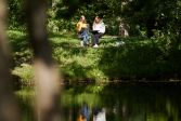
The National Land Survey of Finland (NLS) has selected ten new acts of sustainability to be promoted this year.
Sustainability -
 Read more about Apply for an internship at the National Land Survey!
Apply for an internship at the National Land Survey!
The summer intern application season has started at the National Land Survey. We are once again offering many interesting internships in various parts of the country.
NLS -
 Read more about The new geoid model makes satellite positioning 30 percent more accurate
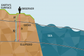
The new geoid model makes satellite positioning 30 percent more accurate
The new geoid model benefits all users of satellite positioning, including smartphone users and a number of societal sectors from transport to construction.
ResearchFinnish Geospatial Research Institute (FGI)Satellite positioning -
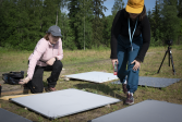
 Read more about Take a look at Meiju and Teppo's career paths at the National Land Survey
Take a look at Meiju and Teppo's career paths at the National Land Survey
Meiju has recently graduated as a surveyor (B.Eng., Surveyor) and Teppo has worked in the field for more than 20 years. What are their thoughts on the surveying field and the National Land Survey as a workplace?
SurveyingNLS -
 Read more about FGI's researchers measure the movements of Earth’s crust in Antarctica
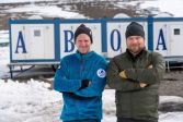
FGI's researchers measure the movements of Earth’s crust in Antarctica
Tammikuusta helmikuuhun 2024 suomalaistutkijat tekevät Etelämantereella mittaustöitä, joiden avulla saadaan tarkempaa tietoa mannerjäätikön sulamisen vaikutuksista merenpinnan nousuun. Toisena tärkeänä tehtävänä on globaalin paikannustarkkuuden parantaminen uusien laitteiden avulla
Finnish Geospatial Research Institute (FGI)ResearchSatellite positioning -
 Read more about Renovation ready at the service point in Kuusamo
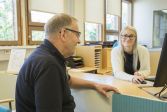
Renovation ready at the service point in Kuusamo
The service point will be closed on Tuesday 9 January due to the move and reopen on Monday 15 January 2024.
NLSCustomer Service -
 Read more about Price changes at the National Land Survey of Finland as of 1 January 2024
Price changes at the National Land Survey of Finland as of 1 January 2024
The National Land Survey of Finland will change its pricing as of 1 January 2024. The prices will be increased due to the increase in the general level of costs, which has been faster than expected in 2023.
NLSServices -
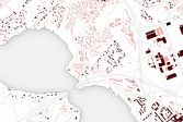 Read more about Historical Topographic Databases now available as harmonised versions
Historical Topographic Databases now available as harmonised versions
The harmonised format makes it easier to use the datasets that are available in the Paituli download service.
ResearchFinnish Geospatial Research Institute (FGI) -
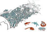 Read more about Climate and geospatial data of European countries on a single platform for the first time
Climate and geospatial data of European countries on a single platform for the first time
The goal of the Location Europe platform developed by the National Land Survey of Finland (NLS) is to especially facilitate solutions that support energy efficiency. The Finnish Innovation Fund Sitra selected the platform in the list of the most interesting solutions in the data economy, which was published on 12 December.
Spatial dataFinnish Geospatial Research Institute (FGI) -
 Read more about Spruce bark beetle damage can be monitored with remote sensing
Spruce bark beetle damage can be monitored with remote sensing
Sufficiently early detection and risk management help control tree damage caused by spruce bark beetles. Remote sensing enables new methods to detect damage already when swarming begins.
ResearchFinnish Geospatial Research Institute (FGI)
More information
For media
Our Communication Services assist media representatives in finding needed information, photographs and experts.