News and articles
-
 Read more about The National Land Survey participates in a digital security exercise
The National Land Survey participates in a digital security exercise
The National Land Survey is participating in Taisto, the largest digital security exercise in Finland, on 30 November 2023. The sixth Taisto exercise gathers hundreds of organisations from various branches of society to practice in preparation for current threats.
DigitalizationServices -
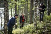
 Read more about Acts of sustainability: Smart facilities and sustainable procurement chains
Acts of sustainability: Smart facilities and sustainable procurement chains
The National Land Survey of Finland (NLS) is committed to advancing 50 acts of sustainability in its sustainability programme by the end of 2027. The programme consists of four themes: data to serve society; people who feel well; sustainable environment; and sustainable way of working and economic sustainability.
Sustainability -
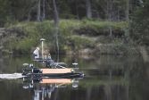 Read more about A digital water system which behaves like an actual one to be created
A digital water system which behaves like an actual one to be created
The Digital Waters flagship, a cluster of top research specialising in water systems, will be established in Finland to develop solutions to protect water resources.
ResearchFinnish Geospatial Research Institute (FGI)Laser scanning -
 Read more about Acts of sustainability: Competence development and cooperation between teams
Acts of sustainability: Competence development and cooperation between teams
The National Land Survey of Finland (NLS) is committed to advancing 50 acts of sustainability in its sustainability programme by the end of 2027. The programme consists of four themes: data to serve society; people who feel well; sustainable environment; and sustainable way of working and economic sustainability.
Sustainability -
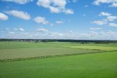 Read more about Acts of sustainability: Environmental goals are reflected in land consolidation and preliminary seizures
Acts of sustainability: Environmental goals are reflected in land consolidation and preliminary seizures
The National Land Survey of Finland (NLS) is committed to advancing 50 acts of sustainability in its sustainability programme by the end of 2027.
Sustainability -
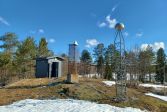 Read more about The 30-year-old network of FinnRef stations forms the basis of Finland’s geospatial data
The 30-year-old network of FinnRef stations forms the basis of Finland’s geospatial data
Our society uses geospatial data round the clock. This would not be possible without FinnRef, Finland’s network of GNSS base stations, which turns 30 this year. Over the years, stations have been replaced by more modern ones, and at the same time, their number has been increased to respond to the growing need for geospatial data in society.
Spatial dataResearchSatellite positioning -
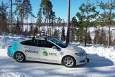 Read more about Self-driving cars can soon detect slippery road surfaces
Self-driving cars can soon detect slippery road surfaces
This winter, the self-driving car of the Finnish Geospatial Research Institute (FGI) of the National Land Survey of Finland (NLS) will operate in normal traffic to collect data about challenging traffic conditions. It allows researchers to train AI to detect any slippery parts of the road and other adverse factors to help autonomous vehicles also operate in winter conditions in the future.
Finnish Geospatial Research Institute (FGI)ResearchLaser scanning -
 Read more about Acts of sustainability: More electronic tools and less unnecessary material
Acts of sustainability: More electronic tools and less unnecessary material
The National Land Survey of Finland (NLS) is committed to advancing 50 acts of sustainability in its sustainability programme by the end of 2027.
Sustainability -
 Read more about Sustainability and efficiency in agriculture and forestry – free coaching for 200 companies
Sustainability and efficiency in agriculture and forestry – free coaching for 200 companies
The National Land Survey of Finland accelerates the use of location data in agriculture and forestry, among others, by coordinating the new Location Innovation Hub.
Spatial dataFinnish Geospatial Research Institute (FGI) -
 Read more about A virtual version of reality, digital twin, makes decision-making and testing easier
A virtual version of reality, digital twin, makes decision-making and testing easier
A digital twin can be, for example, a virtual model of a built or natural environment. In the level of whole Finland, an important basis for digital twins is provided by the National Land Survey of Finland's national laser scanning and aerial photography data.
Spatial dataResearch
More information
For media
Our Communication Services assist media representatives in finding needed information, photographs and experts.