News and articles
-
 Read more about Acts of sustainability: Data and solutions to benefit society
Acts of sustainability: Data and solutions to benefit society
In its sustainability programme, the National Land Survey of Finland (NLS) is committed to advancing 50 acts of sustainability by the end of 2027. This news article provides information about the acts of sustainability in 2024, related to the theme of Data to serve society, and the progress made with them.
SustainabilitySpatial data -
 Read more about Acts of sustainability: Diversity promoted through recruitment and competence development
Acts of sustainability: Diversity promoted through recruitment and competence development
In its sustainability programme, the National Land Survey of Finland (NLS) is committed to advancing 50 acts of sustainability by the end of 2027. This news article provides information about the acts of sustainability in 2024, related to the theme of People who feel well, and the progress made with them.
Sustainability -
 Read more about Automated decision making takes a leap forward
Automated decision making takes a leap forward
Automated decision making, or more officially the automated resolution process, means that a system, not a person, resolves applications submitted by customers.
ServicesDigitalization -
 Read more about Halti heartstone replaced – review of state boundary between Norway and Finland peaked
Halti heartstone replaced – review of state boundary between Norway and Finland peaked
This summer, border commissions from Finland and Norway carried out fieldwork related to the review of the state boundary between the two countries along their national border.
Spatial dataNLSMaps -
 Read more about Satellite failure significant risk to society – UN issues warning for members
Satellite failure significant risk to society – UN issues warning for members
UN issued a strong call to action in New York for members to ensure the operation of satellite services. National Land Survey of Finland Prof. Hannu Koivula and DG Pasi Patrikainen were Finland’s representatives at the meeting.
Satellite positioningResearchSpatial data -
 Read more about Price increases as of autumn 2024
Price increases as of autumn 2024
The increase in the general VAT rate and the amendments to the fees regulation proposed by the Ministry of Agriculture and Forestry may increase the prices of the National Land Survey of Finland in November 2024.
NLSServices -
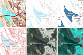
 Read more about Fresh study reveals Finland's best berry picking spots
Fresh study reveals Finland's best berry picking spots
Finland’s forests are a veritable treasure trove for berry pickers. However, finding the spots with the best hauls is difficult. Our study creates berry maps by combining growth location data, geospatial data and laser scanning to find the best spots.
ResearchSpatial dataMaps -
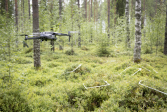
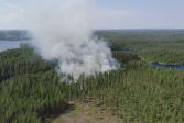 Read more about Drones trained to put out forest fires
Drones trained to put out forest fires
AI-based technology for detecting and preventing forest fires is under development in a project headed by the National Land Survey of Finland’s Finnish Geospatial Institute (FGI). In future, drones and artificial intelligence may help with suppressing fires.
Finnish Geospatial Research Institute (FGI)Research -
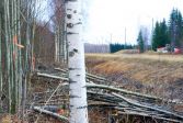 Read more about Measurements ensure that no privately owned trees are felled
Measurements ensure that no privately owned trees are felled
This summer, the Centre for Economic Development, Transport and the Environment (ELY) of North Savo will cut roadside trees over some 250 kilometres to improve traffic safety. Some roads will be repaved while others will undergo structural improvements. The National Land Survey of Finland (NLS) will mark the boundaries of road areas.
Press releaseCadastral surveyReal property -
 Read more about Which interface should I choose – contractual or open access?
Which interface should I choose – contractual or open access?
The National Land Survey of Finland’s (NLS) open datasets are provided through contractual services subject to a separate charge and through open access interfaces free of charge. Is there any difference, and which service should I choose?
InterfacesSpatial dataReal property
More information
For media
Our Communication Services assist media representatives in finding needed information, photographs and experts.