Finnish Geodetic Institute (now Finnish Geospatial Research Institute FGI) has made GPS-based deformation studies at the investigation areas of Posiva Oy since 1994, when the network of ten GPS pillars was established at the Olkiluoto nuclear power station. In 1996, a network of seven GPS pillars was built at Kivetty and Romuvaara, which were candidate sites for nuclear waste deposit. The GPS network at Olkiluoto was later extended with four new pillars and connected in the larger Satakunta area network. The whole network at Olkiluoto is measured twice a year, and since 2003, precise levelling is also made in the area to monitor minor height changes. The episodic measurements will be replaced in the future by continuously observing stations, which will increase the accuracy and reliability of observations.
Finnish bedrock is very old and stable, but it contains cracks and deformation zones where minor movements are possible. Land uplift generates stress in the crust, which is released as earthquakes. The magnitude of the earthquakes is generally very small, and the expected movements are minor. Therefore long-term geodetic observations are needed to detect and monitor these minor movements. GPS and levelling can reveal even sub-millimetre movements, but this requires even decade-long observations.

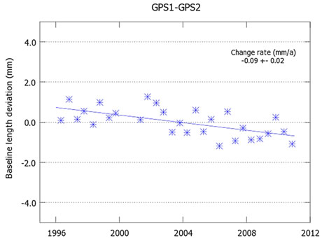
Figure 1. Relative motion between pillars 1 and 2 in Olkiluoto is smaller than 1 mm/yr.
The largest movements in Olkiluoto obtained with GPS are below 0.2 mm/yr, and levelling also shows some anomalous uplift. Measurements will also be continued in the future, but instead of episodic campaigns, GPS observations will be continuous. With continuous observations, one can obtain the same accuracy in a few years as with decade-long observations made twice a year. In the same time, one can better see minor temporal variations and times of possible movements. It is essential to nuclear safety to monitor and understand even these minor movements around the nuclear power stations and in the future at the nuclear waste deposit sites.
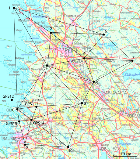
The Finnish Geodetic Institute, the Geological Survey of Finland, Posiva Oy, and the cities of Pori and Rauma launched the GeoSatakunta research program in 2002 to carry out interdisciplinary studies on the regional bedrock stress field and to apply the results in land use planning in the Satakunta area. As part of the project, FGI established a regional GPS network in 2003, which was expanded at its southern part by six new pillars in 2005-2006. During the first years, measurements were made three times per year but currently once every few years to monitor possible long-term movements. Significant movements have not yet been detected.
The Satakunta network is used also by local cities and municipalities for their land surveying purposes. The network is well-suited as the basic reference network, and it is the best known reference network in Finland of this size. Points are freely and easily accessible for local users, who can attach their instruments directly on stable concrete pillars.

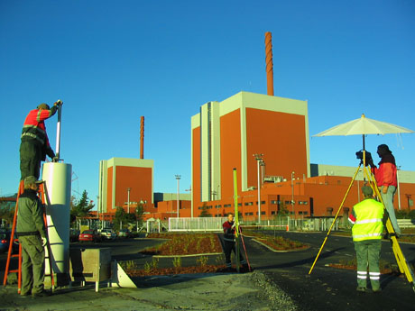
Figure 2. Levelling at the Olkiluoto nuclear power station.
The Finnish Geodetic Institute, the Geological Survey of Finland, Posiva Oy, and the cities of Pori and Rauma launched the GeoSatakunta research program in 2002 to carry out interdisciplinary studies on the regional bedrock stress field and to apply the results in land use planning in the Satakunta area. As part of the project, FGI established a regional GPS network in 2003, which was expanded at its southern part by six new pillars in 2005-2006. During the first years, measurements were made three times per year but currently once every few years to monitor possible long-term movements. Significant movements have not yet been detected.
The Satakunta network is used also by local cities and municipalities for their land surveying purposes. The network is well-suited as the basic reference network, and it is the best known reference network in Finland of this size. Points are freely and easily accessible for local users, who can attach their instruments directly on stable concrete pillars.

Figure 3. GeoSatakunta network. OLKI is point 1 in the Olkiluoto network.

